PCT Permits and Their Effect on my Sanity

Yesterday was insanity.

No amount of preparation, reading, or relaxation beforehand would’ve or could’ve prepared me for the process of applying for my PCT permit.

Here’s a little breakdown:

The permit is necessary for any thru-hiker (which is any hiker travelling 500 miles or more in a single continuous trip). It is our allowance to hike as well as camp on trail. It’s our entry into specific areas and trailheads. It’s mandatory.

With the shift by 2.5 months for permits, my entire class was scrambling to build itineraries, some of us needed travel VISA’s and in order to get that we needed a firm start and end date; give or take a week or so. So that was one extra headache no one really needs, but we were prepared that at 10:30 November 1, it was game time. There are only 50 permits issued for each date. The reason is to spread out the hikers therefore eliminating the affect on the ecology and easing the stress on the trail and resources, as well as the trail angels that assist. They release 35 of the 50 permits in the first batch, and the remaining 15 in January so essentially there were thousands of people trying at the same time to get April dates, which are the most popular. By the time people got through the process they had already timed out the system, meaning most people had to try again, myself included which resulted in my losing April 9th as a start date, i had to go with April 2.

After i submitted the permit, I received a confirmation screen, but no follow up email…which carries my permit ID and portal access to check on the status of my permit. That was when I started to question whether or not I had actually got the application in. After freaking out enough to call, i learned my application was received and I did indeed have a permit ID number…..HUGE sigh of relief.

Now, reality sets in.

I leave to begin my hike in less than 150 days.

Shit just became real!!!

Because of the one week adjustment to my itinerary, I’ll need to ensure before I leave i know how to properly utilize crampons and ice axes. before then i need to get my resupply boxes and address labels ready for the two rockstars who will be mailing my food. I also need to raise $6000. Therein lies the biggest challenge.

Once again, thank you all for being there with me through this whole process…..you’ve kept me sane, grounded and focused. i am eternally grateful to each and every one of my amazing supporters! Keep those waves and honks coming!

178 days out

It’s so hard to believe that I’m 6 months out from the Pacific Crest Trail. I can’t even put into words most days what I’m feeling without using the same lines:
“super excited/jazzed/scared/terrified/insert-random-feeling-adjective here”

OR

“Yeah….it’s going to be great”

OR

“Yeah…..I’m out every morning. No I’m not crazy, and no I don’t camp because I’m homeless” (that has seriously been asked!)
My reasoning behind walking 4 hours per day is simple….if i can make 12 miles per day on the schedule i have NOW, then when my hiking days are 8-10 hours in length on the PCT, I should have NO problem finishing in my timeframe and making 20 miles per day.

The truth is, I’m overwhelmed.
I’m scared I won’t reach my monetary goal in time. To work this hard and have my effort come down to dollars and cents is devastating. To put a dollar value on a dream seems unfair, but it is reality. I’m about $6,000 short. the funds that came in when i first started the push went to help purchasing my dehydrator, pack, groceries for dehydrating, my thru-hiking course and gear purchase. $6,000 is what i’d like in my account to ensure that my focus is putting one foot in front of the other, and not where my next meal will come from when I’m thousands of miles from home.

i’m overwhelmed by how much support I get daily. These walks have turned into way much more than i ever thought they’d be. I’ve met new friends, reconnected with old friends and have a support network of people I don’t even know! Little by little though, I find I wave and smile more every morning between 6:30-8 than I don’t. What an incredible feeling…complete strangers finding so much inspiration in my routine that they take time out of their day to say ‘way to go’, honk or even wave. thank you. Being up that early during all types of weather is not fun sometimes, but it’s people like you that take the time to wave that makes the daily grind more worth it.

I’m also still adjusting to my new size. that in itself has been the biggest hurdle, coming to terms with the new ‘me’. i started my weight loss journey in January 2014 at 255lbs (according to my doctor)….I’m 115lbs. I’ve lost 140lbs. People I’ve known for years don’t recognize me, most days I don’t recognize myself. I can’t say i blame them. when I started to lose weight, I did it because i hit the ‘wall’…the point where you are fed up enough to make a change no matter how you do it. My weight loss was that for me. I hated myself and i knew in order to bring my best self forward I needed to find her. These days, i receive a lot of attention, some of it inappropriate but mostly people just wanting to know what i’ve done. If you’ve seen me pounding the pavement morning, noon and afternoon you know how I did it. I’ve been relentless, but because of that, i find I need more discipline to NOT move then i need to actually move. Between that, clean eating and tracking steps and distance daily, step by step, little by little, i reached my goal-then i surpassed it.

I hope this discipline and drive follows me from california all the way to Canada.

it’s been an amazing, incredible and uplifting journey to say the least. For those that are there for me, you have no idea what that support means. As a supporter myself, it’s hard to ask for help, and as a bit of an introvert, when I do ask for help, i can’t always word what it is I need help with. This Thanksgiving i was grateful for all of YOU. Those waves, honks, smiles and questions are exactly what I need to move forward!

[wpdevart_countdown text_for_day=”Days” text_for_hour=”Hours” text_for_minut=”Minutes” text_for_second=”Seconds” countdown_end_type=”date” end_date=”09-04-2018 07:00″ start_time=”1507833756″ end_time=”0,1,1″ action_end_time=”hide” content_position=”center” top_ditance=”10″ bottom_distance=”10″ ][/wpdevart_countdown]

How is it March already???

I ran into a friend at the drugstore today.  Telling them about this blog made me realize I really should do an update. (so sorry)

Things are going well.  I bought a new truck in January, the comfort and security of having a vehicle as ambitious as me is a relief.  I’m not so concerned about getting stuck up these insane mountain roads anymore, although it’s happened once…just last week.

I’ve jogged or walked every morning with the exception of two mornings in the last 6 weeks.  And just this week I’ve begun walking with my pack.  There’s about 25lbs in it now…over the next several months, I’ll steadily increase the weight and the distance I travel each morning.  I’m up to a few kilometres every morning, although I usually average  5km before I start my shift at the radio station.  I usually walk down hill then jog up, although there’s no jogging with the pack on, at least not right now.  Not desiring an injury, I’m fully taking advantage of the less than 400 days I have left before I leave.

i finally finished that damn game that held up my thru-hiking course for weeks, now i can get started again and advance through my curriculum, however putting it on pause totally took the wind from my sails.  I have to schedule study time or else it won’t get done.  Of course I’m blaming it on training, but I also need to realize the thru-hike course IS also part of my training.

I’m feeling pretty good for the most part these days.  this thursday, I’m taking my hike plans live to FB at 7pm.  If you want to check out the feed, add me to FB Janine Wilson.  I’ll discuss the gear I’m using, set it up on live TV, explain my plans, show my food, and answer any questions people may have.  You should definitely check it out…hell you don’t even need to leave home!

I also cannot wait until spring gets here and I can begin hiking and camping for real without the creature comforts of having a vehicle nearby when I’ve been dumb enough to camp in a billion degrees below zero.  That in itself will definitely help with the training and experience of what the PCT will bring me in 2018.

Practise camping

Monday I just got back from Pine Lake where I spent 3 nights in the wilderness in sub zero temperatures – in a freaking one man tent. It got to minus 4 one night, that’s when I knew I was completely out of my mind. But I had so much fun!!!!!

I got off work the Friday afternoon and headed 12km straight up the W. Kalum FS road to pine lake. My camp was set up within 15 minutes and I was already contemplating what to make for dinner…4 hours early!  I settled on Mac and cheese for my first night. 

I didn’t get as much hiking in as I originally intended. I wasn’t aware of trail conditions for the entire loop and between you and me, I’m somewhat paranoid to leave my really expensive gear unattended. I guess that’s something I’ll have to get over. But it was also insanely chilly I think my body was almost trying to hibernate. So I was compassionate with myself. I decided that if I wanted to drink candy cane hot chocolate and do word searches one afternoon instead of heel toe it around the trail, I was going to be okay with it. The reality is on the PCT there are going to be days where I’d rather die than hike, I need to remember to treat myself with kindness during those days…my journey is a marathon, not a sprint!  This was a really good lesson to learn. 

The next time I go camping on my own, I’ll be a little less forthcoming with my location. The Saturday night of my trip I was asleep in my tent. I woke up in the middle of the night because my bladder was calling on me. As I was just starting to come to, I heard something behind the music I was lightly playing to give myself some white noise in amongst the insane quiet. It sounded like a vehicle. I woke up, paused the tunes and sure enough I could hear a Diesel engine come down the road straight at my site —- AT 12:30 IN THE FREAKING MORNING!!!!!! My heart was pounding the entire time and the guy got pretty close to my camp, within 20ft. I was instantly thankful I chose pine lake and chose to have my vehicle with me. The person didn’t bother me at all, just simply stopped as soon as they saw my gear, turned around and left. But I’ve seen enough scary movies to know how wilderness trips alone for a five ft blonde girl never usually work out well in the movies…I promptly got out of my tent with my sleeping bag and locked myself in my car until I was sure they were gone. I still don’t know who was there but if it was some random person looking for a place to pull over and party, he really chose the woods…pine Lake takes about 30 minutes to get to…and that road sucks!!!! So needless to say, I’ll be a little less vocal about my spots moving forward, for safety sake!

One other extremely awesome lesson I learned was about ‘trail magic’…. the concept is thru-hikers when they’re feeling the most down and out and ready to quit their hike, some miracle or magic happens to make them rethink quitting. Sunday night, I was really beat and tired of being cold. I honest to god considered going home. I knew it would take me 10 minutes to break down camp (if that) and I’d be home by 7pm to ‘Netflix and chill’. I was literally contemplating leaving when I was looking northward and saw the brightest, slowest, clearest meteor I have ever seen!!! It took 30 seconds to get out of eyesight and when it passed over the lake, it lit the lake up!!!!!!  I knew then and there I wasn’t going anywhere and I proceeded to watch the Leonids, by myself on a starry clear night. I packed up Monday as planned feeling great!!!!

Trail magic could be a thru-hiker with an extra beer or Big Mac, a cache of water when hiking through the desert heat when there’s no reliable source for at least 20 miles…it could be a ride to town from the trail or an extra bag of granola in a hiking box when you just ran out. Trail magic exists and I got to understand the awesomeness that is “trail magic”  in person, or at least somewhat of the concept. 

Dehydrating food has slowed down over the past several weeks, but these camping trips are great because I’m trying out my recipes before I depend on my cooking in a real world situation. At least at home if my food sucks, I can drive and get some. Over the winter I’ll be replenishing my inventory and dehydrating once again, now that I’ve tasted my food and know what I like, to build my cache up for my trip. 

What an adventure already and I haven’t even started the PCT!


New Gear

The other day I went to Prince George for an MRI for my left shoulder.  Thank goodness my training regimen hasn’t adversely affected my shoulder.  While I was in the city, I decided to utilize the last of my gift cards for Atmosphere and buy myself my hydration bladder for my pack, a pack cover, and trekking poles.  I’ve been using the hydration pack since I got it Wednesday afternoon.  I literally bought my gear, went to my appointment, then went hiking…in the pouring rain.  I had purchased my pack cover the following day, AFTER my bag got soaked lol.  I anticipate a lot of wet hikes in my future.

I’ve been telling more and more people about my plans and for the most part, people are just as excited as I am.  There’s this slight air of terror as well when I tell them the distance, as people often confuse the PCT with the West Coast Trail….”That’s the one on Vancouver Island, right?”….uh no!  When I tell them then trail spans from Mexico to Canada, they then look at me with this incredulous face.  Then comes the flurry of questions;

“How long will that take?” ————–5.5 months (approx.)

“Is anyone going with you?”————unless people join me for section hikes, nope, I’m on my own.

“What does Scott think of this?”——-obviously he isn’t thrilled at the prospect of me being gone for like 6 months, but I think he knows how important this is to me and that we will find a way to make it work.  This hike is important to me because it signifies a dream I had over 10 years ago, and the work it took me to make it a reality.  This isn’t just personal growth I’m talking here, and my confidence in myself, this is 70+ lbs shed and the way I’ve chosen to put my new body to the ultimate test.

“You’re going to walk the whole thing?” ——-That’s the plan

“at once?!?!”————-yes!

I’m 1026 days away, and spending that entire time preparing myself for this hike.  Trust me when I say I’m seriously working towards this goal, as crazy at is.  I will be prepared when I start in Campo, Mexico and will test myself with every step!  I cannot wait!

The feat itself, broken down

Climbing Mount Everest is a feat so enormous, so dangerous, so daunting, that few people consider it, much less actually do it. Yet more people have scaled Mount Everest, the world’s tallest mountain, than thru-hiked America’s Pacific Crest Trail. How can that possibly be?

Because the Pacific Crest Trail (PCT), quite simply, is a beast.

pct_overview_1pg1


The trail stretches 2,650 miles (4,265 kilometers) from Mexico to Canada along the crests of the Sierra and Cascade mountain ranges, passing through six of North America’s seven ecozones en route. As it zigs and zags through California, Oregon and Washington, it climbs nearly 60 major mountain passes, traverses three national monuments and seven national parks and crosses the San Andreas Fault three times. Hikers can be parched in desert terrain one day, then using ice axes to stop a treacherous fall the next. Thru-hiking the PCT — hiking it in one season — generally takes five to six months. Climbing Everest? Just several weeks.

Think heat, sun and thirst, and you’ve got a good idea of what the PCT’s initial 648-mile (1,043-kilometer) section is generally like. The trail begins in a hot, dusty spot near Campo, a small town on the Mexican border at an elevation of 2,600 feet (793 meters). It winds through chaparral, scrub oaks and pines while temps soar to 90 and even 100 or more degrees Fahrenheit (32.2 to 37.7 degrees Celsius). There’s little shade. Water sources are often 20 miles (32 kilometers) or more apart.

The highest point in this section of the PCT comes in the San Jacinto Mountains, where the path rises to 9,030 feet (2,752 meters) and winds around granite peaks, subalpine forests and mountain meadows; it then plunges to its lowest spot (1,190 feet/363 meters) in San Gorgonio Pass. The trail continues across the San Andreas Fault Zone and western Mojave Desert, then enters the Sierra Nevada and the Central California section

The Southern California portion of the PCT is home to rattlesnakes, poison oak and flies, plus the innocuous-sounding Poodle Dog bush, a pretty, purple-flowered plant that can cause anything from a mild rash to severe respiratory distress if you touch it, or even if you touch clothing that has come into contact with the plant.

The Central California section (505 miles/813 kilometers) is known for its beauty and remoteness. The path traverses the stunning Sierra Nevada, which contains the lower 48 states’ highest mountain, deepest canyon and longest wilderness. No kidding. When I walk this entire section, I’ll climb 13,180 feet (4,017 meters) all the way up to Forester Pass, the trail’s highest point, and in one area I’ll be walking 200 miles (321 kilometers) in the wilderness before the path crosses a road.
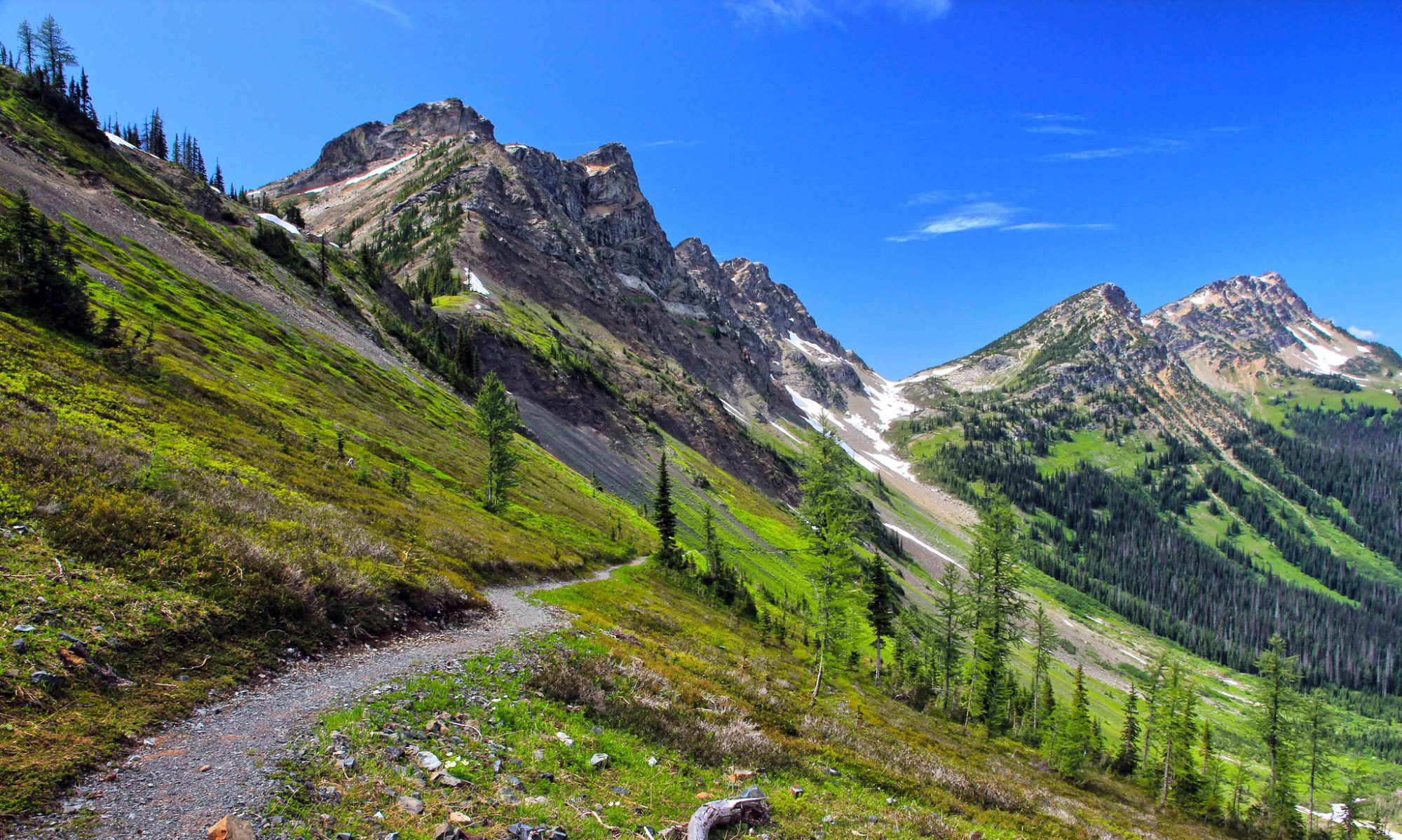
But the scenery is worth it. I’ll be hiking through expansive meadows and conifer forests, then dip into deep canyons and rise up high saddles, all while surrounded by picturesque flora such as corn lilies, snow plants, red fir, Jeffrey and ponderosa pine, mule ears, mountain hemlock and white bark pines. I’ll probably spot critters like the marmot, coyote, deer, black bear, junco, Steller’s jay and mountain chickadee.

With the arid desert climb behind me, the main challenges here come in the form of streams that are easily swollen by melting snows tumbling down from mountaintops and potentially icy high-mountain passes. Hikers here are advised to carry an ice axe and know how to self-arrest, which is a tricky, but highly effective, maneuver you use to stop yourself if you’re sliding down an icy or snowy slope.  For this reason, I’ll be registering in a winter climbing and survival course.

The 567-mile (913-kilometer) Northern California section takes hikers away from glaciated mountain terrain and into the volcanic Cascade mountain range. My Mothership! The lakes disappear, and hiking can get hot and dusty in late summer as the PCT now winds among old volcanic flows and ancient bedrock. it meanders through Lassen Volcanic National Park, which sits in the shadow of Lassen Peak (10,457 feet/3,187 meters). Continuing on, I’ll be able to see impressive Mount Shasta in the distance for quite some time.

When I reach Chester, just south of Lassen Volcanic National Park, I’ve reached the PCT’s halfway point!!!

Oregon’s 430 miles (692 kilometers) are the easiest on the entire PCT, with gentle climbs and well-graded paths that run through cool, shady woods. Thru-hikers often are able to put in their first 30- and even 40-mile (48- to 64-kilometer) days here.

The landscape is still volcanic; I’ll see volcanoes along the skyline such as Mount Hood, Mount Jefferson, the Three Sisters and Diamond Peak. But it’s not stark. There’s an abundance of berries to sustain me here: blackberries, huckleberries and salmonberries, to name a few!!!

The Washington section of the PCT features the Northern Cascades, which offer up dramatic, mountainous scenery , including Mount Rainier, which I’ll be able to see for many days. Rainier is the most glaciated peak in the lower 48, and an active volcano to boot. This is also the section with the most varied weather, as the North Cascades Range lies in a storm track most of the year. I can count on it being green and pretty wet overall. But all of this moisture results in a soggy-but-beautiful hike, including a trek through Glacier Peak Wilderness, which features numerous switchbacks and rolling hills — challenging, but beautiful — plus 750 snowfields (areas perennially covered with snow) and small glaciers.

The PCT officially ends in the middle of the wilderness at the Canadian border. To make it easier to get back to civilization, the Canadian government created another 7 miles (11.2 kilometers) of trail that connect the PCT with Highway 3 in British Columbia’s Manning Provincial Park.

thMH37AT5D


Training Hard


I’ve taken my new pack out 3 times for hikes in the past two weeks, once at Gunsite with Scott, once to Sleeping Beauty and once up Terrace Mountain.  All three times, I’ve increased the weight…the first walk there was maybe 10lbs on my back, for Sleeping Beauty I increased the weight to 20.6lbs and for Terrace Mountain I carried 27.8lbs.

IMG_3131

It felt so good to be up there carrying my pack…which is completely and utterly amazing by the way.  It really doesn’t feel like I’m carrying the weight I am.  It’s very misleading. The pack is so comfortable when it’s on.  It holds loads quite well, is sturdy and definitely reliable. I’m planning on hiking at least twice per week for the summer.  Not only will I get closer to my weight loss goal but I’ll also get conditioned to carrying weight for long distances.  I’m so glad I bought my pack when I was in Cowtown.

I’m about $100.00 shy of buying my dehydrator for my trip.  I’m looking at the Excalibur dehydrator, 9 trays, back fan so it doesn’t need as much maintenance and fan cleaning as a unit with a bottom fan, and it has the ability to dehydrate multiple items as once.  It keeps going on sale so I’m hoping it drops a bit more so I can get it (and get to dehydrating) sooner.

I’ve grabbed a couple books on the PCT and downloaded the Halfmile PCT app, the same provider of my maps and course.  I’ve been checking out others’ blogs and reading Backpacker magazine for tips and gear ideas.  Remember, I have a wishlist at REI.com if you’re interested in becoming a sponsor for my hike.  The link to my wishlist is:

https://www.rei.com/WishlistView?id=70b084d6-bfcb-4c29-841a-16a7925cc55f

Mid-month I’m heading to PG for a medical scan and I plan to buy the hydration bladder for my pack so I can stop filling space with bottles of water.  When I bought my pack I got a gift certificate for $50 off at Atmosphere, luckily for me PG has an Atmosphere :D.  I may buy my trekking poles as well.

This planning business is exciting!!!  I find I’m telling more and more people now.  Talking about it makes it feel more real.


Helpful advice

My step sister-in-law came up last week for a visit, she’s an avid backpacker. So naturally she was excited about my pending hike and dished out tons of helpful advice including what to look for in a pack and possibilities for my re-supply.  She’s a great source of information!  We might even get together a few times over the coming years before my trek to practise.  I of course invited her to hike a leg of the PCT with me!

I showed her my PCT binder, that I’ve affectionately nicknamed Ogre, it’s friggin huge.  A 3 1/2 inch binder jammed full of maps, elevations, shopping lists, resupply plans, etc.  I obviously cannot bring Ogre with me on my hike, but for now, it’s my PCT bible!

The Itinerary

It took a few days longer than I’d hoped to post this, but I definitely have a solid first draft itinerary.  It feels real now, like this is actually going to fucking happen!

My hike will start Mid-April which means I’ll be reaching the finish line roughly the second week in September in Manning Park BC.  I’m telling you I want a finish line party!  Best friends- TAKE NOTE!

I’m shooting for 20 miles at least per day…there are some days where I’ll have extra, especially if I have to hike or hitch into towns off the PCT.  I kept 20 miles even towards the end, although there’s a very good chance I’ll be capable of doubling that by Oregon as California is the toughest trek of the PCT.  I just need to be super careful about straying too far off this itinerary, especially when resupply and bounce boxes come into play.  I don’t want to get too far ahead of myself, then I could run into trouble with post offices, food amounts, etc.

I also built in about 18 resupply locations (I’m breaking those down into necessary portions) so I can ensure food meets me regularly on my trip without the extra unnecessary weight.  Man this hike planning takes a lot of thought. Looks like I resupply anywhere from 4-10 days, when you think at most there will be 40 meals on my back in dehydrated pouches, it doesn’t seem so overwhelming.  Thank goodness REI and Mountain house have good variety!  The menu should be online within a few days as I fully plan to work on my meal and resupply schedule over the New Years weekend.

I’m hoping to meet up with friends along the trail and have some company for part of the trip, especially my hubby. I spoke with my best friend Tyson and if he’s nearby we’ll definitely meet, if not have him come along for a bit.  That’ll be tres cool! Some cities I’ll stopover for a couple nights stay, those are usually the locations where there’s motels, laundry and grocery facilities.  Some locations, I’m simply stopping by to pick up a resupply box and I’ll carry on to the next campsite.

Any suggestions or changes you think I should make?  Any places I’ve missed that I definitely need to add?  I wanted to add MSH to my hike, but it’s at least 50 miles one way out of my way!  There won’t be resupply locations and very little traffic.  Not the smartest trek even though it’ll kill me to see her and not be closer!

PCT_1stdraftITINERARY


Topographical maps and their effect on my sanity

Why didn’t I pay better attention in Geosciences when we studied topographical maps? I found a really cool site that has downloadable maps that lay out EVERYTHING on the PCT including safe drinking water stops, post offices, stores, elevations, abandoned forest roads, camp sights, etc. After staring at it for hours, I am just starting to figure out my journey and how to fucking plot it. These maps are intense!!!! Not only is the writing horrendously small but for only the first 200 miles of the “hike from hell” I’ve printed off over 50 sheets of maps, resources and elevation logs. Perhaps turning my nose at a $30.00 map purchase online was rather ridiculous. Although I have to admit planning this over the past couple of days has been exhilarating.  Going through page by page of my printouts makes me feel as if I’m building my journey and customizing it.   I have the first week rough planned including potential camping areas, re-supply locations and have mapped out approximate hiking distances. I’m shooting for a minimum of 20 miles per day. I don’t think this is unreasonable and I’m bound to cover more ground daily the more I hike. Not only will my body be conditioned to the conditions and elevation changes, I’ll be in rocking shape!

I also downloaded a PCT planner where I inputted potential dates and with my goal of 20 miles per day, I’m looking at 6 months to do the whole thing. Yikes!  I’d rather not be on my own for that length of time, so I may have to consider lightening the load by using the “bounce box” strategy. This is where hikers ship a package to post offices along the trail for themselves and it contains things you definitely need in between re-supply boxes but not necessarily right this minute.  If you need something, the box will greet you at the next stop, which is usually no more than 50 miles away and you can restock the next time you resupply in town.  If you don’t need anything you simply re-seal it and forward to yourself at the next pick up location on the trail. For thru-hiking this idea is pure fucking genious.  Not only are you not carrying extra weight, you can simplify the whole experience.  I am NOTORIOUS for over-packing, just ask my husband.

These are my bounce box ideas, if you can think of any other ideas let me know:

  • Laundry detergent pads
  • feminine products <—–(sorry, guys!)
  • Ziploc Slider 1 gal bags
  • Cell charger
  • Mophie charger
  • Fitbit charger
  • Batteries
  • Camp fuel x2
  • Toothbrush, toothpaste, razor
  • Sewing kit
  • Waterproof matches
  • Mailing labels, stamps, envelopes, pens, paper
  • Packing and duct tape
  • Water treatment drops
  • Toilet paper
  • Butane
  • Soap
  • Deodorant
  • Individually sealed medications
  • Floss
  • Shampoo/conditioner
  • Dish soap
  • Moleskin
  • Journals
  • Clean underwear and socks
  • Garbage bags

I’ll scan my first week into my blog over the next day or so. It’s rough draft, but a good start. Especially for a hike that is at least a few years away.

Have I mentioned I’m jazzed?